Goldfields
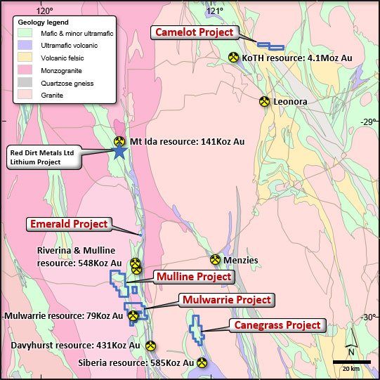
The Goldfields Project includes several sub projects called:
- Mulwarrie Sub-Project (E30/511, P30/1141, P30/1142 and P30/1143)
- Mulline Sub-Project (E30/512 and E30/513)
- Canegrass Sub-Project (E29/1010)
- Emerald Sub-Project (M30/110)
- Camelot Sub-Project (E37/1417 and E37/1418).
- 100% ownership of 10 tenements totalling 295km2 in the prolific Goldfields region of Western Australia.
- Project area is close to existing mines, key infrastructure and mining support services (120km WNW of the modern mining town of Kalgoorlie).
- Along strike from the historic Mulwarrie Mining Centre, which contains the Mulwarrie Gold Mine.
- Similar regional geology to Red Dirt Limited’s recently acquired Mt Ida Li-Cu-Au project.
The Goldfields Project comprises of six granted exploration licences, three granted prospecting licences and one granted mining licence, together cover an area of 104 Blocks within the Archaean volcano-sedimentary Norseman-Wiluna Greenstone Belt located in the Yilgarn Craton of Western Australia.
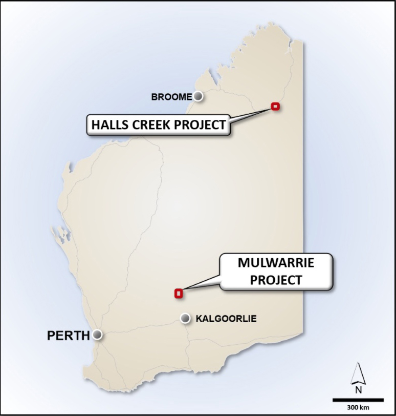
The Goldfields Project is located approximately 120km WNW of Kalgoorlie, and 500km ENE of Perth in the Eastern Goldfields Region of Western Australia. The project is accessed from Coolgardie via the unsealed Coolgardie North and Davyhurst-Mulline roads. The Mulwarrie, Mulline and Emerald Projects are along strike the Mt Ida and Davyhurst Mines.
The Mulwarrie Project is located adjacent to the historic Mulwarrie Mining Centre, which contains the Mulwarrie Gold Mine and is approximately 12km to the WNW of the Davyhurst Mine that is currently owned and run by Ora Banda Mining Limited (ASX: OBM). Gold was first discovered in the Mulwarrie area in 1898. Subsequent discoveries were made along a north-westerly strike of 10km. Gold mineralisation occurs in structures both parallel to and cross-cutting the regional trend. Strong alteration to biotite, diopside, and epidote, as well as silicification and sulphide development, is present in the structures. Mulwarrie Project has previously been covered by soil sampling and aircore and reverse circulation (RC) drilling. Several gold prospect targets have been identified, namely the Northern Extension, Io, and North Io Gold Targets within the Mulwarrie Project.
The Mulline Trend covers an area of approximately 20km2. It is associated with the high surface gold anomalism associated with “laterite” gold deposits. Primary gold mineralisation is associated with quartz and sulphide veins that occur in shear zones within basalt and dolerite units. Mineralisation is also associated with porphyry units that have intruded the mafic sequence. The majority of work conducted over the Mulline tenure happened between 1996 and 2008 including laterite and soil sampling, rock chip and RAB drilling.
Historically pegmatites have been identified to the east of the project area in the vicinity of Lady Gladys West prospect. Geochemical analysis of the pegmatites was not undertaken at the time, so it cannot be confirmed if they are Lithium bearing.
Several targets have been produced based on significant results from both historic surface geochemistry and drilling activities, namely the following:
- Northern Extension, Io, and North Io Gold Targets within Mulwarrie Sub-Project;
- +9.2km strike at +10ppb gold in vacuum soil anomaly within Mulline Sub-Project;
- Potentially high-grade Emerald Sub-Project; and
- Western and Central gold in soil anomaly and the two nickel-in-soil anomalies within Canegrass Sub-Project.