Halls Creek
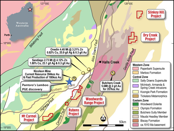
The Halls Creek Project includes several sub-projects, called:
- Woodward Range Sub-Project (E80/5034)
- Rubens Sub-Project (E80/5220)
- Mt Carmel Sub-Project (E80/5154)
- Dry Creek Sub-Project (E80/5148 and E80/5025)
- Slinky Hill Sub-Project (E80/5149).
- 100% ownership of 6 tenements totalling 348km2 in the highly prospective East Kimberley region of Western Australia.
- Tenements pegged by the vendors over historic gold occurrences along 100kms of strike accessible from the town of Halls Creek.
- Significant historic alluvial gold mining throughout the area but very limited exploration directed towards finding the source of the gold.
- Targeting intrusion related style gold mineralisation discovery initially at Woodward Range.
The Halls Creek Project comprises of six granted exploration licences, together cover an area of 110 Blocks (~340km2) located in the Kimberley Region of Western Australia and accessed from Halls Creek via the Great Northern Highway.
The Halls Creek tenements are located along the south-eastern margin of the Archean Kimberley Craton within the Proterozoic aged Halls Creek Orogen of Western Australia. The Halls Creek Orogen has a long history of intermittent reactivation until the end of the Palaeozoic. The majority of tenure sits within the Olympio Formation, with some covering parts of the Biscay Formation. Deformed and metamorphosed Olympio Formation was intruded by post‐1820 Ma granites of the Sally Downs Supersuite.
The rocks of the Halls Creek Orogen are highly deformed, with significant folding and faulting having occurred through several orogenic events. There are some large structures that could be crustal-scale and offer the potential for focusing significant fluid movement, which is important for the formation of gold deposits. There also appeared to be numerous local scale structures that can localise ore-forming fluids to form deposits.
The Halls Creek tenement packages are largely underexplored, and the potential remains for several different styles of mineralisation to occur. Several projects contain drill-ready prospects, from extensional AC-RC to infill RC drilling, including Woodward Range, Dry Creek, Rubens and Slinkey Hill.
Other prospects require further work in detailed geological mapping, close-spaced stream sediment, soil, auger soil and rock chip sampling; to delineate potential drill-ready targets. Completing relevant geophysical surveying over the projects will also aid in the process of delineating these prospects and potentially lead to the identification of new ones.
Woodward Range
Woodward Range is the most advanced project in the Halls Creek group with the three distinct NE-SW gold trends identified; Leonardo to the North, Glenbuff in the central part of the tenement and Garden Creek at the southern end. RC drilling at Glenbuff was conducted by Panorama over a continuous strike of ~920m, with a few other lines drilled nearby. The drilling intersected nine intervals +1g/t with the best result of 3m @ 5.77g/t Au from surface in AGP037. RC drilling at Glenbuff Southwest was conducted by Panorama over a continuous strike of ~600m. The drilling intersected six intervals +0.5g/t with the best result of 1m @ 8.41g/t Au from 22m in AGP049 (A43612)
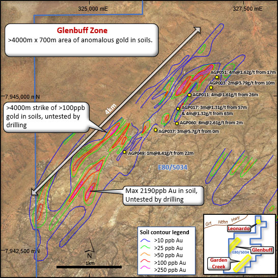
Significant intersections from Glenbuff and Glenbuff Southwest includes:
AGP051: 4m @ 1.62g/t Au from 17m
AGP003: 2m @ 3.79g/t Au from 10m
AGP011: 4m @ 1.61g/t Au from 26m
AGP037: 3m @ 5.7g/t Au from 0m
AGP017: 3m @ 1.31g/t Au from 57m & 4m @ 1.32g/t Au from 63m
AGP060: 8m @ 2.61g/t Au from 2m incl. 3m @ 4.71g/t Au from 3m
AGP049: 1m @ 8.41g/t Au from 22m